The Lorain County zoning is vital for residents, property owners, and developers. From lot splits to major subdivisions, and zoning amendments to official maps, this guide explains processes, forms, and approvals. Learn how to navigate planning regulations, attend commission meetings, and access township-specific resources to ensure safe, legal, and efficient land use decisions in Lorain County, Ohio.
Township and City Zoning Maps: Essential Planning and Zoning PDFs
The Lorain County Community Development Department provides PDFs for all planning, zoning, and subdivision forms. Accessing these resources ensures compliance and streamlines applications for minor or major subdivisions.
| Document | Purpose |
|---|---|
| Minor Subdivision Checklist | Required for lot split applications |
| Minor Subdivision Variance Application | Apply for exceptions in minor subdivisions |
| Minor Subdivision Brochure | Overview of minor subdivision process |
| Major Subdivision Application | Submit application for developments with 5+ lots |
| Preliminary Plan Checklist | Requirements for preliminary major subdivision |
| Final Plat Checklist | Requirements for final approval |
| Major Subdivision Variance Application | Apply for exceptions in major subdivisions |
| Conditional Use Permit Application | Request conditional land use approval |
| Fence Permit & Neighbor Consent Form | Required for fencing near property lines |
| Lot Split Application | Submit request for minor lot division |
| Plat Approval Application | Submit request for plat approval |
| Written Notice of Appeal | Appeal zoning decisions |
| ZBA Variance Application | Request variance from zoning board |
| Zoning Reclassification Application | Request change in zoning designation |
| Get All PDF |
Lorain County Planning Commission
Lorain County Planning Commission manages zoning amendments and subdivision reviews for 18 unincorporated townships. Their decisions guide legal land use, ensure safety, and promote organized growth across the county.
Official Zoning Map
Meeting Location & Schedule
Planning Commission meetings are held in Meeting Room A, 4th Floor, County Administration Building, 226 Middle Ave, Elyria, Ohio. Meetings are monthly, and residents can submit requests at least 8 days before each meeting.
Role of the Commission
The Commission reviews zoning amendments, provides recommendations, and collaborates with township officials. Their guidance ensures that development projects align with safety, community standards, and long-term land-use plans.
Minor Subdivisions (Lot Splits)
Minor subdivisions involve small land divisions, typically fewer than 5 lots. They are ideal for property owners splitting parcels or creating new residential lots.
Application Process
Applications for minor subdivisions are submitted to the Community Development Department anytime. All submissions must include the checklist, variance application (if required), and brochure to ensure compliance with county regulations.
Requirements
Applicants must provide property details, lot plans, and supporting documents. Compliance with zoning laws, adjacency rules, and township guidelines ensures timely approval and avoids delays in the lot split process.
Major Subdivisions
Major subdivisions involve 5 or more lots or extensions of roadways. These require extensive review to maintain safe and organized development.
Review Process
The Subdivision Review Subcommittee evaluates all major subdivision plans, checks compliance with county regulations, and submits recommendations to the Planning Commission for final approval.
Documentation Needed
Developers must submit the application, preliminary plan checklist, final plat checklist, and variance application if necessary. These documents ensure the project meets legal, environmental, and safety requirements.
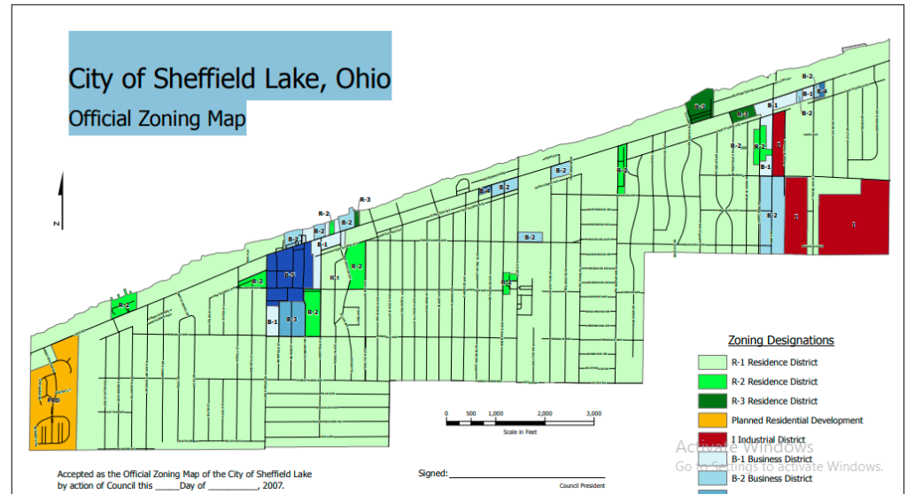
Township & City Zoning Maps
Official zoning maps show land-use designations for each township, helping property owners and developers plan construction or purchases effectively.
How to Use Maps
Maps indicate residential, commercial, industrial, and agricultural zones. They guide decisions about building permits, land purchases, and compliance with county planning regulations.
List of Township Maps
The list of key township and city zoning maps in Lorain County:
- Amherst Township
- Brighton Township
- Carlisle
- Columbia
- Eaton Township
- Elyria Township
- Grafton
- Huntington Township
- LaGrange Township
- New Russia Township
- North Ridgeville
- Penfield Township
- Sheffield Lake
- Wellington Township
Residents can access all maps online to check zoning before construction or development projects.
Planning & Zoning Goals
The Lorain County Planning & Zoning Code ensures safe, organized, and lawful land use. It promotes public health, economic development, and long-term community planning.
Zoning Code Background
The new zoning code, Ordinance 4-21, became effective in February 2021. It was developed collaboratively with the Planning Commission, City Council, and Building, Housing & Planning Department to reflect community needs.
Administrator Role
The Planning & Zoning Administrator enforces zoning regulations, reviews permits, processes applications, and provides guidance to residents and developers to ensure compliance with the law.
Efficiently handling property documents requires the right gear. For professionals, I highly recommend checking out these [Essential Office Tools] that help speed up the scanning and filing process.
Conclusion
Lorain County Planning & Zoning is critical for property development, safety, and organized growth. By using official PDFs, attending meetings, and consulting zoning maps, residents and developers can make informed decisions and avoid legal complications.
FAQs
What is Lorain County zoning?
Zoning in Lorain County determines how land can be used residential, commercial, industrial, or agricultural. It sets regulations for construction, safety, and land development, ensuring that properties comply with community standards and long-term planning goals. Residents and developers must consult maps and codes before any development.
How do I find my property’s zoning?
To find your property’s zoning, check your township’s official zoning map or contact the Lorain County Community Development Department. These maps indicate land-use classifications and help you understand permitted activities, restrictions, and requirements for building, lot splits, or conditional uses before submitting applications.
What is the difference between minor and major subdivisions?
Minor subdivisions involve splitting a parcel into fewer than five lots, usually for small-scale residential purposes. Major subdivisions involve five or more lots or any road extension. Major subdivisions undergo a more detailed review process, requiring subcommittee recommendations, preliminary and final plans, and compliance with county regulations.
How do I submit an application for a variance or conditional use permit?
Submit applications directly to the Planning & Zoning Administrator at the Community Development Department. Required forms include Conditional Use Permit, Lot Split, Variance, and Plat Approval applications. Ensure all supporting documents, property details, and checklists are complete to avoid delays and meet the official submission deadlines.
Where can I access Lorain County zoning maps?
Lorain County zoning maps are available online for each township and city. These maps help property owners, developers, and researchers determine land-use classifications, building restrictions, and zoning boundaries. Always consult the relevant map before starting any construction, lot split, or zoning change request.FAQs
What is Lorain County zoning?
Zoning in Lorain County determines how land can be used—residential, commercial, industrial, or agricultural. It sets regulations for construction, safety, and land development, ensuring that properties comply with community standards and long-term planning goals. Residents and developers must consult maps and codes before any development.
How do I find my property’s zoning?
To find your property’s zoning, check your township’s official zoning map or contact the Lorain County Community Development Department. These maps indicate land-use classifications and help you understand permitted activities, restrictions, and requirements for building, lot splits, or conditional uses before submitting applications.
What is the difference between minor and major subdivisions?
Minor subdivisions involve splitting a parcel into fewer than five lots, usually for small-scale residential purposes. Major subdivisions involve five or more lots or any road extension. Major subdivisions undergo a more detailed review process, requiring subcommittee recommendations, preliminary and final plans, and compliance with county regulations.
How do I submit an application for a variance or conditional use permit?
Submit applications directly to the Planning & Zoning Administrator at the Community Development Department. Required forms include Conditional Use Permit, Lot Split, Variance, and Plat Approval applications. Ensure all supporting documents, property details, and checklists are complete to avoid delays and meet the official submission deadlines.
Where can I access Lorain County zoning maps?
Lorain County zoning maps are available online for each township and city. These maps help property owners, developers, and researchers determine land-use classifications, building restrictions, and zoning boundaries. Always consult the relevant map before starting any construction, lot split, or zoning change request.